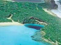
Springfield, Missouri – October 25, 2010 — A team of researchers has uncovered evidence that a Mega-Flood, or series of megafloods, from beneath the Ice Age Laurentide Ice Sheet shaped the Bahama Islands. These Mega-Floods traveled down the Mississippi River Valley and into the gulf of Mexico.
These
Megafloods entered the Gulf, rapidly raising the water level and forcing the overflow out through the many smaller Florida/Cuba Straits. This Glacial overflow then spread across the lower lying area known as the Bahama Mega-Bank. 12,000yrs. ago, (with sea levels at least 300 ft. lower than today) the Bahama Mega-Bank was an exposed land mass larger than present day Florida.
The megafloods originated from Glacial Lake Agassiz. Lake Agassiz was an Ice Age Lake formed by receding Glaciers, and covered an area of roughly 365,000 square miles. It was the largest lake in the world. The megafloods from Lake Agassiz traveled down the 120 mile wide, 600 mile long Mississippi River Valley. The Mississippi Valley covers an area of 35,000 sq. miles and was itself cut out by this same Ice Age flooding. The Ice Age melt water through this valley fed into the Gulf of Mexico.
PRO-GLACIAL LAKE AGASSIZ= The 10,000 ft thick Ice Age Glaicers depressed the surrounding land mass as much as 3,000 ft. Water accumulating in this depression is called a Proglacial Lake. It means, “in front” of the glacier. Glacial Lake Agassiz was the largest of many such proglacial lakes.
SUB-GLACIAL LAKE= The Ice Age Glacier did not melt just from the top down. It melted from underneath as well. As the depth of the Ice Sheet increased, the pressure at the bottom increased enough to lower the freezing point of water below the temperature of the ice above it. This allowed liquid water to form into huge under ice lakes. Water under pressure requires a lower temperature to freeze than surface water.
This melt water would accumulate into depressions and Valleys and form giant under ice lakes. Also, the Proglacial Lakes that formed up against the ice sheet, would undercut the ice and bleed underneath it to form lakes.
This same type of Subglacial Lakes has been identified beneath the Antartic ice sheet.
According to scientists from the University of Edinburgh, 386 subglacial lakes have been identified buried beneath the Antartic ice sheet.
GLACIAL OUTBURST= These under-ice lakes were subject to process known as Glacial Out-Burst A Glacial Outburst could occur when the ice above a Subglacial Lake could no longer support its own weight and would compress down into the water. This could squeeze the trapped water out in tremendous outburst.
The warmer Pro-Glacial Lake water along the leading edge of the Ice Sheet would melt miles back beneath the 10,000 ft. thick Ice Shelf. This melting would occur along stretches hundreds of miles in length. Eventually, the under-cutting of the ice Sheet by warmer Lake water would stretch so far beneath the super thick Ice Shelf that it could no longer support its own weight.
When the 10,000 ft Ice Shelf dropped into a Sub-Glacial Lake, its entire contents would surge out and into Lake Agassiz and overtop the Lake edge along areas the length of entire states. We have termed this process, “Burping”.
This process is not to be confused with an ice or sediment dam collapsing and releasing vast amounts of glacial water through a narrowly selected area. It was more like getting into an overfilled bathtub and the water overflowing the entire rim of the tub at once.
As lake Agassiz overflowed the smaller proglacial lakes below Agassiz (some the size of states), would fill and burst their banks and then cascade into yet another lake below it. The isostatically depressed northern region, which would have been the natural direction of run off for these lakes, was blocked by the 10,000 ft thick Laurentide Ice Sheet. This ice sheet formed a dam and forced the filling of these lakes until they rose high enough to break through the southern Sediment Dams created when the Ice Sheet was advancing.


