The Southern Islands of The Bahamas are are being threashed with winds and heavy rain.
As the eye of Hurricane Irene passed over Crooked and Acklins Islands, it was still a category three hurricane with maximum sustained winds of 115mph.

No deaths or serous injuries have occurred but damage to house and buildings has been reported.
Some power lines are down and the electricity went off around 8:00am. Cell phones are operational and some land lines are working.
In Acklins, winds are so strong that residents who are not already at the island’s only shelter can no longer travel to get there.
Irene is forecast to strengthen and could become a category four hurricane in the next 24 hours as it barrels down on Nassau, expecting to arrive Wednesday night or Thursday morning.
Grocery stores, hardware stores, water depots and gas stations across New Providence were jammed this morning, with people grabbing the necessary supplies before hurricane weather hits Nassau.
Hurricane Irene exhibits an unmistakably visible eye surrounded by very tall thunderstorms on satelite imagery. Ingestion of this dry air and some wind shear probably adversely affected Irene’s health last night, but strengthening has resumed. Further intensification is expected as it continues to move over 85+F water and effectively fends off the environmental resistance. The storm may well reach category 4 levels with peak winds of 135 mph.

Significant impact to New Providence is possible including torrential rain, coastal flooding and damaging winds.
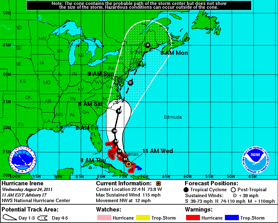
As of 11:00am, Irene is located near latitude 22.4 north, longitude 73.9 west, around 100 miles southeast of Long Island, about 287 miles southeast of Nassau.
Irene is travelling northwest at 12mph and this general motion is expected to continue tonight, with a turn toward the north-northwest, and then the north, expected by Thursday.
On the forecast track, the core of Irene will move across the southeastern and central Bahamas tonight and over the northwestern Bahamas on Thursday.
The latest minimum central pressure reported by reconnaissance aircraft was 956 mb, 28.23 inches.
Airports
The Lynden Pindling International Airport on New Providence Island will cease operations at 2:00pm today and is scheduled to reopen at 5:00pm on Thursday, August 25. The Grand Bahama International Airport will close at 10:00pm tonight and tentatively reopen 2:00pm on Friday, August 26.
In the Family Islands; Normans Cay, Staniel Cay, Exuma International, San Andros, Fresh Creek Andros, Mangrove Cay, Congo Town South Andros, Nicoll’s Town North Andros, North Eleuthera, Rock Sound and Governor’s Harbour Eleuthera will all close at 2:00pm today and reopen at sunrise on Thursday, August 25.
Most airlines have already provided additional airlift out of the Bahamas as the Ministry of Tourism, the Bahamas Hotel Association and the U.S. Embassy have all recommedned leaving the Bahamas if possible.
The U.S. Embassy has temporarily closed preclearance facilities at Lynden Pindling International Airport and Freeport International Airport. Once the facilities are closed, all passengers travelling to the United States will require a valid US passport or valid US visa to present to US Customs officials upon arrival in the United States. Bahamians will not be allowed to travel to the United States on Wednesday with a police certificate. Check with the Embassy website for information on when the preclearance facilities will resume operations.
Effective now, all visa services have been suspended until Tuesday, August 30. If you have an appointment during this closure time, visit the US Embassy website for rescheduling information. The website also provides information on procedures for U.S. citizens and others who must travel to the U.S. on an emergency basis.
Category three hurricane Irene is only the third hurricane since 1866 to threaten the entire Bahamas archipelago, according to the Bahamas Meteorology Department.


