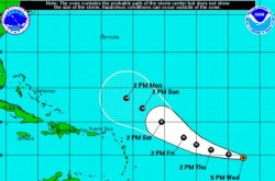
 Tropical Storm Katia, currently located about 1,285 miles east of the Leeward Islands, is likely to become a hurricane on Wednesday night.
According to the National Hurricane Center in Miami, at 5:00 pm EDT on Wednesday, Katia was moving toward the west-northwest near 20 mph and this motion with a gradual slowing of forward speed is expected over the next 48 hours.
Maximum sustained winds have increased to near 70 mph, with higher gusts. Additional strengthening is forecast during the next 48 hours.
Katia is continuing to move to the south of a subtropical anticyclone. The west-northwestward track is expected to continue for the next couple of days with some deceleration as the tropical cyclone nears a weakness in the ridge.
Computer models show a turn toward the northwest as Katia approaches the southwest side of the subtropical anticyclone.


