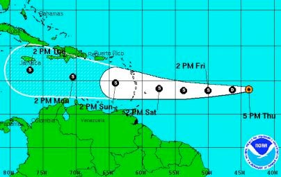
A new tropical depression formed in the tropical Atlantic on Thursday, with a forecast track that takes it through the Caribbean hard on the heels of Tropical Storm, later Hurricane Ernesto.
Accodring to the National Hurricane Center in Miami, at 5:00 pm EDT on Thursday, the centre of tropical depression seven was located about 1,155 miles east of the Windward Islands, moving toward the west near 20 mph. This general motion is expected to continue for the next 48 hours.
Maximum sustained winds are near 35 mph, with higher gusts. Slow strengthening is forecast during the next 48 hours and the depression could become a tropical storm on Friday.
Interests in the Windward Islands should monitor the progress of this system.
Meanwhile, a low pressure trough — the remnants of Tropical Storm Florence — is producing an area of disorganized showers and thunderstorms several hundred miles north-northeast of the northern Leeward Islands. Although upper-level winds may become a little more conducive over the next couple of days, significant redevelopment of this system is not expected at this time. This system has a low chance — 10 percent — of becoming a tropical cyclone again during the next 48 hours.
Another tropical wave, accompanied by an area of low pressure, is approaching the west coast of Africa with minimal shower and thunderstorm activity. Some development of this system is possible over the next couple of days as it moves westward at 10 to 15 mph. This system has a low chance — 20 percent — of becoming a tropical cyclone during the next 48 hours.


