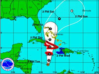
 Hurricane warnings have been issued for eastern Cuba and Jamaica as Tropical Storm Sandy was expected to strengthen into a hurricane by the time it nears Jamaica on Wednesday.
According to the National Hurricane Center in Miami, at 5:00 pm EDT on Tuesday, the centre of Tropical Storm Sandy was located about 260 miles south-southwest of Kingston, Jamaica, moving toward the north-northeast near 6 mph. A north-northeastward to northward motion at a faster forward speed is expected over the next 48 hours.
On the forecast track, the centre of Sandy will move near or over Jamaica on Wednesday afternoon and near or over eastern Cuba on Wednesday night.
Maximum sustained winds are near 50 mph, with higher gusts, and Sandy is expected to strengthen into a hurricane by the time it nears Jamaica. Tropical storm force winds extend outward up to 105 miles from the centre.
Tropical storm conditions were expected to reach Jamaica on Tuesday night or early Wednesday, with hurricane conditions expected on Wednesday. Tropical storm conditions are expected in portions of Haiti on Wednesday. Hurricane conditions are possible in eastern Cuba by Wednesday evening or Wednesday night. Tropical storm conditions are possible in the central and southeastern Bahamas on Thursday.
Sandy is expected to produce total rainfall amounts of 6 to 12 inches across Jamaica, Haiti, the Dominican Republic and eastern Cuba, with isolated maximum amounts of 20 inches possible. These rains may produce life-threatening flash floods and mud slides, especially in areas of mountainous terrain. Rainfall totals of 3 to 5 inches are expected over portions of The Bahamas, with isolated maximum amounts of 12 inches.
A storm surge will raise water levels by as much as 1 to 3 feet above normal tide levels along the southern and eastern coast of Jamaica. A storm surge will raise water levels by as much as 3 to 5 feet above normal tide levels in southeastern Cuba. Near the coast, the surge will be accompanied by large and dangerous waves.


