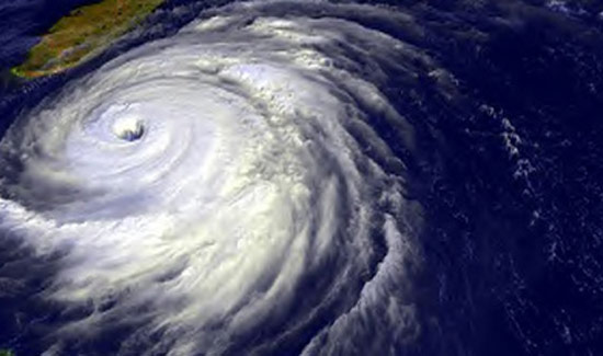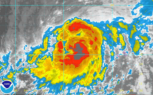
Very early Wednesday morning, Humberto strengthened to become the first hurricane of the 2013 Atlantic Hurricane season.
Maximum sustained winds reached 75 mph, classifying Humberto as a Category 1 hurricane during the overnight hours. As of the midday hours Wednesday, Humberto had strengthened slightly with maximum sustained winds of 80 mph.
There was a chance this hurricane season might set a new record for having the latest first Atlantic hurricane since the satellite era began in the early 1960s. The challenge went down to the wire.
The latest the first hurricane of the season formed was 2002’s Gustav on Sept. 11. Gustav was upgraded from a tropical storm to a minimal hurricane that Wednesday midday, shortly after 8:00 a.m. EDT.
As of Tuesday evening, Sept. 10, there had been no hurricanes thus far during the 2013 season in the Atlantic. However, Humberto brought an end to this by strengthening into a Category 1 hurricane near the Cape Verde Islands early Wednesday morning.
Since Humberto was upgraded to a hurricane prior to the time Gustav became a hurricane on the 11th, the late-forming hurricane record has remained intact.
According to Hurricane Expert Dan Kottlowski, “Humberto has entered an area of the atmosphere with low disruptive winds at midweek.”
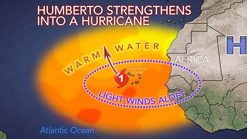
These diminishing winds helped Humberto strengthen to become a Category 1 hurricane.
“Late this week, Humberto is likely to weaken while moving into a zone with drier air and more disruptive winds,” Kottlowski said.
A curve to the northwest and then the north is forecast this week, which will take Humberto over the open waters of the central Atlantic with no serious direct impact to mainland areas.
Locally gusty winds, rough seas and a few squalls will continue to affect the Cape Verde Islands into Thursday, prior to the system moving to the weset and north.
According to Senior Meteorologist Kristina Pydynowski, “the greatest impact from Humberto will be on the Cape Verde Islands this week.” Locally gusty thunderstorms, downpours and rough surf and seas will affect the islands.
Prior to the satellite era, the 1941 season did not deliver an Atlantic hurricane until Sept. 16.
Farther back, there were two years that had no reports of hurricanes in the Atlantic. These were in 1907 and 1914. While it is possible there were no hurricanes during both seasons, there were only five reported tropical storms in 1907 and only one in 1914. Especially, during the latter season, a number of storms may have gone undetected without the aid of weather satellite photos.
Beyond Humberto, there are no strong candidates for hurricanes through the middle of September. However, there may be another tropical depression or storm over the next week to 10 days. Possible tropical depression/storm breeding areas include the western Caribbean, the southwestern Gulf of Mexico and the continued train of disturbances moving westward off of Africa.

The season thus far has treated most populated areas of North America kindly. Sadly, it has claimed lives in Mexico, due to flooding from Tropical Storm Fernand in August.
Late-season storms in some years have been very destructive.
According to Meteorologist Mark Mancuso, “While 2005’s Wilma occurred during the most active Atlantic hurricane season on record, it did not come about until the middle of October.”
Wilma became the most intense hurricane on record in the Atlantic basin, in terms of low atmospheric pressure. Maximum sustained winds reached 185 mph. Wilma killed dozens of people and caused nearly $30 billion in damage from the Caribbean to the eastern United States, Canada and later Europe.
While the season thus far has been tame compared to some years, many meteorologists concur that the 2013 Atlantic hurricane season is not over yet and will not sound the “all-clear” until the weather pattern suggests that.
There will be more systems to monitor over the next two months. Alerts to such systems will be sounded, when appropriate.
There is a chance there are three active tropical systems spinning over the Atlantic basin simultaneously later this week. These include Humberto, Gabrielle and perhaps a system over the southwestern Gulf of Mexico.
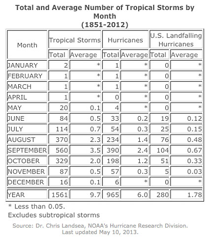
People should consider hurricanes as being just as much of an autumn weather phenomena as well as a summer phenomena. Hurricane season runs from June 1 to Nov. 30.
According to the National Oceanic and Atmospheric Administration, since 1851, there have been 645 hurricanes during the months of September, October and November, compared to 321 hurricanes during June, July and August.
“Even if the large high pressure area and its dry air over the central Atlantic was to hold through the remainder of the season, occasional weaknesses in that system can still allow hurricane formation over the next two months,” Kottlowski said.
By Alex Sosnowski, Expert Senior Meteorologist for AccuWeather.com

